|
||||||||||||||||||||||
Global
Positioning Systems (GPS) MC-GPS
GPS/GIS Data Collector
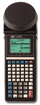
The MC-GPS consists of a rugged, waterproof MC5 handheld computer, an attached GPS antenna and GPS receiver integrated in one convenient, handheld package for multi-layer GIS data collection jobs. The internal GPS receiver is specifically engineered to provide maximum performance under canopy, providing 1-5 meter accuracy with real time or post processing differential correction. Traverse points can be collected and seamlessly integrated into the GIS data set when satellite signals can't be received such as in extremely dense canopy situations with the industry's only built-in traverse function. Setup of GIS data collection lists can be done on the handheld unit with the Field Software, or created before going out to do a job with the PC Desktop software. Version 3.6 Field Software The onboard version 3.6 Field Software will get you up and running quickly with its intuitive, point-and-shoot interface whether you are a newcomer to GPS or an experienced professional. CMT-Field's powerful database functions allow you to tie the detailed data you need to each GPS point - saving you time in the field and increasing your data analysis efficiency in the office. MC-GPS can collect data for three different types of locations: a point (one location, i.e. a corner post, tree or stop sign); a line (a series of points connected together, i.e. a road, trail or waterway); or an area (a line that ends the same place it began, i.e. a lake, park boundary or parking lot). Carrier Phase Package Obtain greater accuracy with the carrier phase option, -CM, which can attain centimeter-level accuracy (10-30 cm) without separate data collectors, antennas or poles. Uploading and processing your carrier phase data in PC-GPS 3.7 is virtually the same as processing C/A code data. The MC-GPS-CM offers the ultimate in flexibility, allowing you to do a variety of tasks. It can be used to record 1 -5 meter data in addition to 10-30 cm data. For example, if you have a job that requires 10-30 cm accuracy on the property corners but only requires 1-5 meter accuracy on the streams running through the property, the MC-GPS would be the perfect tool. It can perform both tasks in the field without skipping a beat. In the past, you would have needed two different types of GPS receivers to do this job. Input
& Output Ports
NMEA 0183 position output allows the MC-GPS to output a GPS position to devices (i.e. Laptop PC, sonar, etc.) that will accept an NMEA 0183 message. There is no need to change your instrument settings. The MC-GPS communications can be set to match your instrument. MC-GPS's flexibility shines when it comes to interfacing with external RS232 instruments such as laser rangefinders and digital calipers. Characters coming in through the COM port appears as if they are being entered through the keyboard. CMT offers a variety of off-the-shelf application software for the MC-GPS. For example, our Surveyor's Assistant software accepts input directly from survey total stations. Or attach a barcode wand to the MC-GPS and you can quickly enter data. Barcode menus can be setup in such a way that the you never need to touch the MC-GPS keyboard. Specifications Version
3.7 PC-GPS Desktop Software PC-GPS 3.7 can be used as part of a complete system with a CTM GPS data collector or as a stand-alone resource mapping program. Best of all, you don't need to be a GIS expert to use it. PC-GPS 3.7 can help you manage your GPS data collection "jobs" from start to finish. Prior to field data collection, you may identify optimal times for GPS reception using Mission Planning. In addition, you may want to Construct a Hierarchical "Feature List" of Features, Attributes, and Values to promote organized and convenient field data collection. Following GPS collection, use our advanced differential correction to improve the accuracy of your GPS data. Finally, export your data to your GIS system or create a complete map within PC-GPS 3.7. The geographic and image data in your Map is automatically organized into layers to facilitate map viewing and data management. Analyze the Feature, Attribute and Value data in your Map using the powerful filter, search and classification tools. Once your Map is created, it can be plotted complete with custom legends, labels and objects. Many of the functions available in more complicated GIS or mapping programs are readily accessible. When you need advanced capabilities, PC-GPS 3.7 provides power beyond standard mapping programs with the support of Microsoft's Open Database Connectivity (ODBC), Object Linking & Embedding (OLE), and Advanced Programming Interface (API). Some formats PC-GPS 3.7 is compatible with are ARC/INFO, ArcView, AutoCAD and ESRI Shape files
| ||||||||||||||||||||||
|
Copyright ©
2001 Geo Scientific Inc., All Rights Reserved |
||||||||||||||||||||||
 The
MC-GPS has two waterproof DB-9 RS-232 serial ports (COM1: and COM2:)
that facilitates communication with a PC and a variety of additional
input and output devices such as an RTCM-104 Realtime DGPS source. Compatible
with the Coast Guard Correction Beacons, obtain real-time differential
correction with CMT's Coast Guard Beacon Receiver package. The MC-GPS
will automatically detect and use the RTCM message from the beacon receiver.
Don't worry if you lose the RTCM message while you are collecting data;
the MC-GPS will automatically warn you and record raw data so you can
post-process your data. You'll never be stuck with uncorrectable data.
Since the MC-GPS has two DB-9 serial ports, you can use COM1 for RTCM
and still have COM2 available for a barcode reader or NMEA output to
another instrument.
The
MC-GPS has two waterproof DB-9 RS-232 serial ports (COM1: and COM2:)
that facilitates communication with a PC and a variety of additional
input and output devices such as an RTCM-104 Realtime DGPS source. Compatible
with the Coast Guard Correction Beacons, obtain real-time differential
correction with CMT's Coast Guard Beacon Receiver package. The MC-GPS
will automatically detect and use the RTCM message from the beacon receiver.
Don't worry if you lose the RTCM message while you are collecting data;
the MC-GPS will automatically warn you and record raw data so you can
post-process your data. You'll never be stuck with uncorrectable data.
Since the MC-GPS has two DB-9 serial ports, you can use COM1 for RTCM
and still have COM2 available for a barcode reader or NMEA output to
another instrument.